2019 IMAGIN MAP GALLERY COMPETITION


Sponsored by North Arrow Technologies, the IMAGIN Map Gallery for 2019 included two online categories in addition to the tradition printed map gallery categories.  Judging in the online categories of Story Maps and Online Mapping Applicaion was performed by the Map Gallery Planning Team the weak prior to the conference, and the judging panel selected the winners of the Cartographic Design and Analytic Presentation categories as part of the IMAGIN Conference on June 11, 2019.  Winners received a certificate and a $50 gift card for their efforts.  

2019 Map Gallery Judges
   James Rutherford - North Arrow Technologies
   Matt Malone - City of Farmington Hills
   Keith Rikli - Giffels Webster


2019 Map Gallery Planning Team

   Keith Rikli - Team Lead
   Rawan Alhabbal
   Matt Malone
   Melissa Salich
   Thomas Van Bruggen
   Terry Zahniser

2019 IMAGIN Map Gallery Results

Printed Map Gallery Competition
All printed maps entered in the map gallery competition are eligable for the Cartographic Design, Analytic Presentation, and Peoples Choice Awards.  Map submissions are not required to select a category and the judging panel is allowed to select from any of the entrants a winner for the judged awards.  The Peoples Choice award is selected by conference attendees during the annual conference.  
Click Thumbnail to
View Full Size Map
1st Place - Cartographic Design
SEMCOG - Delores Lee Muller and Sirisha Uppalapati
A Look at Neighborhood Stability in Southeast Michigan

1st Place - Analytic Presentation
Colleen Long et. al. -  University of Michigan Water Center
Land Management and Agricultural Practices in a Binational Watershed
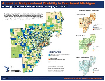
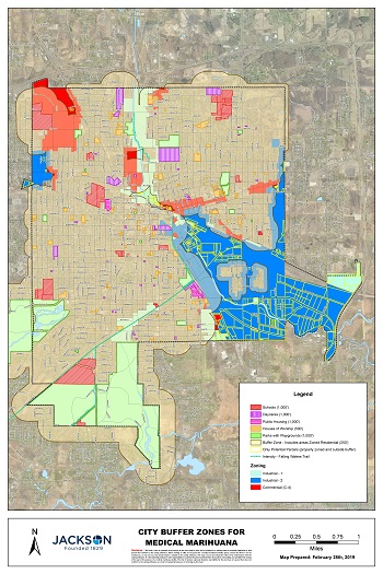
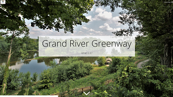
People's Choice: Printed Map Category Winner
Nathan Pinti - Jackson County GIS
Jackson County Published Road Map

Additional Map Gallery Entrants - Listed Alphabetically by Last Name


Brett Dankenbring, Mitchell Hoeksema, Christian Johnson & Andrew Newland
Ferris State University
Mobile LiDAR: Field to Finish
Brent Finilla, Jacob Moyer, & Robert Church
Ferris State University
Retracement Survey

Jacob Los, Jacob Harkema, Jacob Nurenberg, & Adam Gunderman - Ferris State University
Subdivision Design

Shane Pavlak, Ottawa County GIS
Spring Lake Buoy Locations

Abdualrahman Qadi-Zadh, Michelle Thebo, Mohammed Alghfeli, Ahmad Aldrou
Ferris State University
Creating a 3D Building information Model

Wade Renando, City of Jackson
City of Jackson Medical Marihuana Buffer Zones

Jamie Way, West Michigan Shoreline Regional Development Commission (WMSRDC)
Muskegon Lake Area of Concern Remediation & Restoration


Story Map Competition 
Click Thumbnail to
View Story Map
1st Place - Story Map Competition
Mary Clinthorne - Aquinas College
Aquinas College Trees: Past, Present and Future

Honorable Mention - Story Map Competition
Sarah Lagpacan - The Rapid
The Rapid: Laker Line

People's Choice - Story Map / Online App Category Winner
Mary Clinthorne - Aquinas College
Aquinas College Trees: Past, Present and Future

 
The Following Story Map Submissions are listed in Alphabetical Order by Last Name and the order does not indicate any position or scoring
Aaron Bodbyl-Mast - Ottawa County GIS
The Grand River Greenway
Eileen Boekestein - Grand Valley Metro Council
A Grand Restoration
Nichole Bowman - City of Auburn Hills
City of Auburn Hills 2019 Capital Improvement Projects

Magda DiFranco - Clinton Township
Clinton Township Roads - Pavement Conditions

Paige Gebhardt - State of Michigan DNR
Prescribed Burns

Paige Gebhardt - State of Michigan DNR
State Forest's of Michigan Tour

   
Online Mapping Application Competition
Click Application Thumnail to view application if available.

1st Place - Online Map / Application Category
Nathan Hollenbeck - Muskegon County GIS
AmeriCorps - Muskegon County Urban Safety Corps Program Impact Dashboard


Honorable Mention - Online Map / Application Category
Magda DiFranco - Clinton Township
Clinton Township Roads - Pavement Condition Reporter

The following Online Interactive Map / Mapping Application Submissions are listed in Alphabetical Order by Last Name and the order does not indicate any position or scoring
Nichole Bowman - City of Auburn Hills
City of Auburn Hills Road by Management Agency Application
 
Edward Hug: SEMCOG
SEMCOG Pavement Condition Reporting Application
Thomas Van Bruggen & Nathan Hollenbeck - Muskegon County GIS
November 2018 Muskegon County Elections Reporting


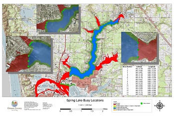
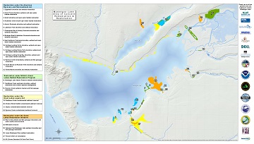
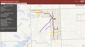
IMAGIN: Improving Michigan's Access to Geographic Information Networks

IMAGIN is a 501(c)3 non-profit organization with offices at 416 S. Cedar Street, Suite H, Lansing, MI 48912

Powered by Wild Apricot Membership Software